Canisteo Area Community: {not inclusive list}
Canisteo Area History
Canisteo existed as a community prior to European settlement, but there are different versions of who the inhabitants were and what the settlement consisted of. In the seventeenth and eighteenth centuries Canisteo was in a remote area, between territories of the Seneca and Delaware Indians, "a sort of No Man's Land". There are references to a "Kanestio castle", but differing accounts of what it was, or even what was meant by "castle". One modern writer calls it " mysterious", noting that "facts about [it] are few and difficult to come by." A well-known version is that of Steuben County historian Harlo Hakes, published in 1896. "The Delaware Indian town which had been dignified by some writers with the name of 'Kanestio Castle'...is said to have contained about sixty hewed log houses, with stone chimneys in each, and to have been the home or seat of operations of a noted 'Delaware King,' known as At-weet-sera." The destruction of the Indian village took place in 1765. At Kanestio they "burned 60 good houses, a vast amount of corn, agricultural implements and saddles." The settlement at Kanestio Castle was eliminated. Early settlers began arriving at what would become a new community around 1789.The village of Canisteo was originally called Bennettsville.The original Canisteo, today a hamlet called Canisteo Center or Carson, was southeast of the present village, along the river. When the Erie Railroad was built in 1850, there was not room for a depot between the tracks and the Canisteo River, so the depot was built upriver, at the south of the tracks, on the west side of Depot Street. A "fairly large settlement", which disappeared in the twentieth century, grew up near the depot, on the north side of the river and tracks. Depot Street (renamed Railroad Street while the trolley ran down it) was built to connect the depot to the Canisteo House hotel. A large community, with businesses and shops, and other hotels, sprang up.
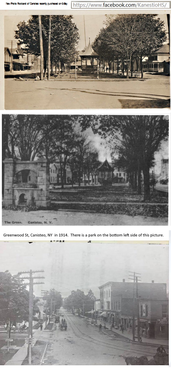
Railroad Street – Greenwood Street was in the nineteenth and early twentieth centuries the principal street of Canisteo. On an 1873 map, Main Street (neither East nor West) stretched from Railroad/Greenwood Street to what was later called Ordway Lane, where the street ended. In the other direction, one traveled north from Railroad/Greenwood Street along Hornellsville Street.
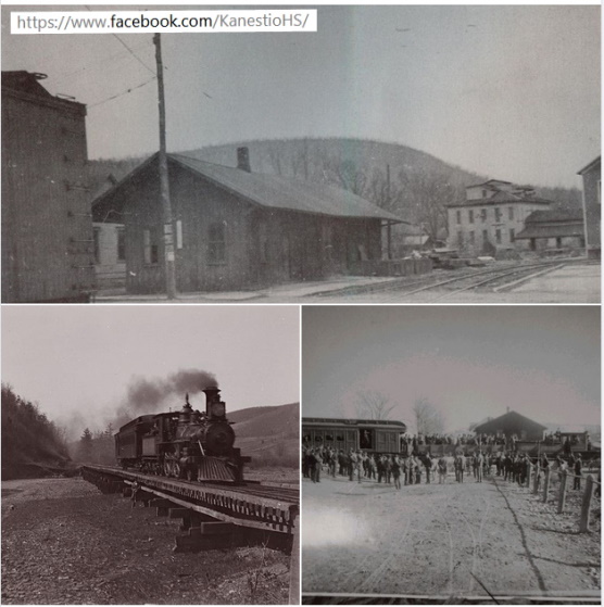 Until 1851, when the Erie Railroad began operations, traffic was via the Canisteo River. The Erie ended that traffic,
although an undated picture, which must be post-Erie since it includes a bicycle, shows a horse-drawn "stage" making
two trips a day to Hornell. Aside from that the Erie was the sole route until 1892, when the Hornellsville & Canisteo
Railway (a trolley line) linked Canisteo with Hornell; the trolley passed by the Erie station, linking it via Depot
Street with the center of Canisteo, over half a mile away. By road, the main connection was the Canisteo River Road,
today (2019) Steuben County route 29 between Canisteo and Hornell, route 119 between Canisteo and Cameron. The new
hard- surface road between Hornell and Canisteo that later became New York Route 36 was built in 1912. (That road was
destroyed by Hurricane Agnes in 1972; the current four-lane route is higher up.) With the growth of automobiles this
replaced the railroad, Depot St. declined in importance, and Hornellsville Street was turned into West Main Street
and the former Main St. into East Main St. All Erie service to Canisteo ended in the 1940s; there were still freight
trains, but none stopped in Canisteo.
Until 1851, when the Erie Railroad began operations, traffic was via the Canisteo River. The Erie ended that traffic,
although an undated picture, which must be post-Erie since it includes a bicycle, shows a horse-drawn "stage" making
two trips a day to Hornell. Aside from that the Erie was the sole route until 1892, when the Hornellsville & Canisteo
Railway (a trolley line) linked Canisteo with Hornell; the trolley passed by the Erie station, linking it via Depot
Street with the center of Canisteo, over half a mile away. By road, the main connection was the Canisteo River Road,
today (2019) Steuben County route 29 between Canisteo and Hornell, route 119 between Canisteo and Cameron. The new
hard- surface road between Hornell and Canisteo that later became New York Route 36 was built in 1912. (That road was
destroyed by Hurricane Agnes in 1972; the current four-lane route is higher up.) With the growth of automobiles this
replaced the railroad, Depot St. declined in importance, and Hornellsville Street was turned into West Main Street
and the former Main St. into East Main St. All Erie service to Canisteo ended in the 1940s; there were still freight
trains, but none stopped in Canisteo.Around 1900, the Erie Railroad had 10 passenger trains each day, the New York & Pennsylvania had 3, and the trolley had 20.[12]:12 In 1891 the New York, Lake Erie and Western Railroad had 3 eastbound and 4 westbound trains per day.[32] In 1892, Canisteo was the terminus of the route to Olean of the Central New York and Western Railway, which bought the assets of the bankrupt Lackawanna and Southwestern Railway Company.[33]
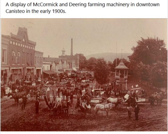
In 1888 Canisteo was described as prosperous. In 1892, 20 arc lights were installed for street illumination. A business directory of 1893 reports that: Canisteo "has a bank, weekly newspaper, four churches, well-equipped fire department, three hotels, and a first-class academy. Very few villages of its size have the industries equal to this place.
Source: Wikipedia.org [Canisteo History]
The town was formed in 1796 at the time of the creation of Steuben County and is one of its original towns. From parts of Canisteo came, in whole or part, the Towns of West Union, Hartsville, Hornellsville (1920), Greenwood(1827), Troupsburg (1808, 1820) and Jasper (1927). A part of the town was annexed to Troupsburgh in 1818. Hornell was originally a village in the town of Canisteo. From parts of Canisteo came, in whole or part, the Towns of West Union, Hartsville, Hornellsville (1820), Troupsburg (1808, 1818), Greenwood (1827), and Jasper (1837).
Source: Village of Canosteo
The name was taken from a former Native American village located there, and is Iroquoian in origin. Canisteo is the site of the largest living sign in the world, noted by both Ripley's Believe it or Not! and the Registry of Historical Places. The original activities in the town of Canisteo were farming and lumbering; the Canisteo River offered transportation for products. After arrival of the Erie Railroad in 1851, the Village of Canisteo was home to a variety of small manufacturers. In the early 21st century Canisteo was the administrative center of the Canisteo Wind Farm, producing electricity from southwestern Steuben County and adjacent areas. The soil is chiefly a clayey and gravelly loam, with rich alluvium in the valleys of the streams; some of the richest lands in the county being the Bennett Flats, at the mouth of Bennett’s Creek. The first settlers conveyed their provisions, baggage, and families, from Newtown (Elmira), on a seven-ton boat, while four sons of Mr. Uriah Stephens drove the cattle along the shore.
In 1890 Canisteo had a professional baseball team. Canisteo got telephone service about 1902. It got dial service about 1950. The original activities in the town of Canisteo were farming and lumbering; the Canisteo River offered transportation for products. After arrival of the Erie Railroad in 1851, the Village of Canisteo was home to a variety of small manufacturers.
In the early 21st century Canisteo was the administrative center of the Canisteo Wind Farm, producing electricity from southwestern Steuben County and adjacent areas.
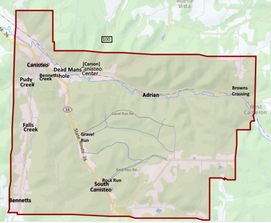
Communities and locations in the Town of Canisteo
[None of these communities are in the Addison School District as only a small amount of country {rural} are in the Addison School District. See the map marked with yellow.]- Adrian – A hamlet in the northeast part of the town, east of Canisteo village on County Road 119 (Canisteo River Road) by the Canisteo River.
- Bennetts – A hamlet to the south of the village, on NY-248 and Bennetts Creek. A flag stop on the New York & Pennsylvania Railroad.
- Bennetts Creek – A north-flowing stream entering the Canisteo River by Canisteo village.
- Browns Crossing – A hamlet by the east town line on County Road 119 (Canisteo River Road) by the Canisteo River.
- Canisteo – The Village of Canisteo, at the junction of Routes 36 (Main Street) and 248 (Greenwood Street), about one mile west of the Canisteo River, County Route 128 (older than NY Route 36), and the former Erie train line and depot.
- Canisteo Center – A hamlet east of Canisteo village on County Road 119 (Canisteo River Road). The original village, until the railway station, over a mile to the north, was built in the mid-nineteenth century.
- Carson – Another name for Canisteo Center (to avoid confusion with Canisteo)
- Dead Man's Hole – A swimming area on the west bank of Bennetts Creek south of Canisteo village and east of NY 36.
- Fall Creek A hamlet to the south of the village but north of Bennetts, on NY-248 and Bennetts Creek. A flag stop on the New York & Pennsylvania Railroad.
- Gravel Run – A hamlet north of South Canisteo on NY-36.
- Purdy Creek – An east-flowing stream entering Bennett's Creek by Canisteo village. "Purdy" is a regional, supposedly uneducated pronunciation of "pretty".
- Rock Run – A location north of South Canisteo.
- South Canisteo – A hamlet southeast of Canisteo village on NY-36.
Canisteo Area that is in the Addison School District [marked in yellow]:
{North and East side of Canisteo only}
 Source:
Wikipedia.org [Cansteo]
GenealogyTrals.com [Canisteo]
Evening Tribune [Canisteo History]
PaintedHills.org [Canosteo]
Wikipedia.org [Canisteo]
Village of Canisteo [About Canisteo]